Westside Jacksonville: a six-ZIP search with distinct pockets.
West Jacksonville · Duval County
The shape of Westside, Jacksonville on the First Coast.
Westside is a broad Jacksonville search west of the St. Johns River and south of I-10. This guide follows a six-ZIP market definition that includes Ortega, Cedar Hills, Jacksonville Heights, Argyle Forest, Oakleaf, and parts of the Normandy and Blanding corridors.
A local realMLS-based summary reports a $255,000 median sold price across the six ZIP codes for the 12 months through October 24, 2026, and about $46 per month in reported median HOA dues among active listings. The region also mixes housing eras, retail nodes, school zones, and commute corridors. Use the dated market figure for comparison, then check the home’s tax record, association documents, school assignment, and actual route by address.
- Median home price
- $255,000 median sold price across ZIPs 32210, 32220, 32221, 32222, 32244, and 32254; trailing 12 months through October 24, 2026.
- HOA costs
- About $46/month reported median dues; 46% of the active listing sample carries an HOA. Property and subdivision costs vary.
- CDD costs
- Unavailable as a Westside-wide measure. Check the parcel tax bill and any community assessment disclosure.
- Median year built
- Unavailable as a median. The local MLS summary describes a typical recent sale as built around 1998, but does not publish a median year built.
- School zones
- Duval County Public Schools; assignment depends on the exact home address, not the Westside label or nearby campus.
- Commute trade
- No consistent Westside-wide commute median is published. Compare the address’s access to I-10, I-295, Blanding/US-17, Normandy, and 103rd at the time you travel.
Westside campuses are reference points; the exact address sets the assignment.
The named Duval County campuses below serve different parts of a broad region. They are examples, not a shared feeder pattern or a guarantee for a nearby home; use DCPS My School Location with the property address.
- ElementaryJacksonville Heights Elementary SchoolDuval County Public Schools lists the campus at 7750 Tempest Street South, Jacksonville, FL 32244. It is a Westside campus reference, not a guaranteed assignment for every home in the six-ZIP area.
- MiddleWestside Middle SchoolThe DCPS campus is at 4815 Wesconnett Boulevard, Jacksonville, FL 32210. A school name or nearby address does not establish the current attendance zone; check the exact property.
- HighWestside High SchoolThe DCPS campus is at 5530 Firestone Road, Jacksonville, FL 32244. It is one local high-school reference, not a blanket assignment across Westside.
The places you actually go in Westside, Jacksonville.
The useful stops sit along separate Westside corridors; the detailed list distinguishes destinations inside the guide area from nearby Orange Park options in Clay County.
Westside routines cluster along several road corridors instead of one walkable center. Oakleaf and Argyle Forest handle much of the large-format shopping, while rail-trail and river-side parks offer quieter outings; the main movie and performing-arts options in this guide sit just across the Clay County line.
- Argyle Forest Boulevard · OakleafFull-service grocery and pharmacy at 9518 Argyle Forest Boulevard, Jacksonville, FL 32222.
- 103rd Street · Oak HillFull-service grocery and pharmacy at 7628 103rd Street, Suite 24, Jacksonville, FL 32210.
What it is like to actually live in Westside, Jacksonville.
Westside works for buyers who want a broad choice of housing settings and practical access to Jacksonville’s west-side corridors. The trade-off is that the area has no single town center: neighborhood character, costs, school assignments, and the best route can change quickly between ZIP codes.
- A regional label with distinct pocketsThe six-ZIP definition includes the riverfront streets of Ortega, established Blanding and Normandy neighborhoods, Jacksonville Heights, and the newer Argyle Forest and Oakleaf growth areas. Compare the exact cross streets rather than assuming the region name describes one housing type.
- A dated price measure, not one uniform marketThe reported $255,000 median sold price is an aggregate across six ZIP codes. The source’s ZIP-level medians range from $174,950 to $320,000, so the market-wide number is a starting comparison rather than a likely price for every pocket.
- Errands follow corridor centersOakleaf Town Center and the Argyle Forest nodes concentrate large-format shopping and services; 103rd Street and Blanding serve other parts of the Westside. That spread favors drivers and makes the nearest grocery or pharmacy an address-level question.
- Commutes depend on direction and departure timeI-10, I-295, Blanding Boulevard, Normandy Boulevard, and 103rd Street connect different parts of the district to Downtown, NAS Jacksonville, Cecil Commerce Center, and Clay County. JTA routes 30 and 31 serve sections of the 103rd and Blanding corridors, but a route nearby does not mean every home has convenient transit.
What Westside, Jacksonville actually looks like.
Locally sourced photographs with author and license attribution beside each image.
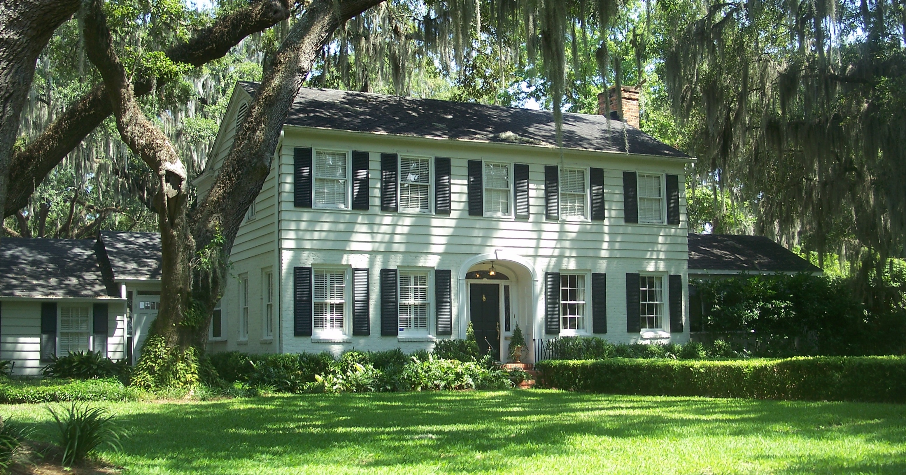
Historic Ortega is one river-side Westside pocket, not a representative view of every neighborhood. “Jax FL Old Ortega HD01.jpg” — Ebyabe — CC BY-SA 3.0 — via Wikimedia Commons.Source: Wikimedia CommonsLicense: CC BY-SA 3.0
Sources, definitions, and what to check by address.
Research checked October 26, 2026. The median sold price and HOA snapshot come from Momentum Realty’s realMLS aggregation for six named ZIP codes and are current as of October 24, 2026; the price is not a property valuation, and the HOA figure is from active listings rather than every home. The source describes a typical home sold as built around 1998 but does not publish a median year built, so that median is unavailable. No consistent Westside-wide CDD cost or commute median was found; verify assessments against the parcel tax bill and test the route from the property at the intended travel time. Duval school assignment is address-specific. The map outline is an editorial orientation, not an official neighborhood, ZIP, parcel, or school boundary. The credited Ortega photograph shows one historic river-side pocket, not the full Westside housing range.
- Momentum Realty — Westside market data and ZIP definition
The realMLS snapshot current as of October 24, 2026 reports a $255,000 median sold price across ZIP codes 32210, 32220, 32221, 32222, 32244, and 32254 for the trailing 12 months, about $46/month in HOA dues, and a typical year built around 1998 (not a median).
- Duval County Public Schools — My School Location
Use the district’s address lookup for the current school assignment. These campus examples do not promise a zone for a nearby property.
- Jacksonville Heights Elementary School — campus information
Confirms the elementary campus at 7750 Tempest Street South in Jacksonville.
- Westside Middle School — campus information
Confirms the middle-school campus at 4815 Wesconnett Boulevard in Jacksonville.
- Westside High School — campus information
Confirms the high-school campus at 5530 Firestone Road in Jacksonville.
- Publix at OakLeaf Plantation Center
Official store page lists 9518 Argyle Forest Boulevard, Jacksonville, FL 32222, with grocery and pharmacy services.
- Publix at Oak Hill Village
Official store page lists 7628 103rd Street, Suite 24, Jacksonville, FL 32210, with grocery and pharmacy services.
- Oakleaf Town Center — property manager and tenant list
The property manager lists the center at 9525 Crosshill Boulevard and identifies its current anchor and service tenants.
- City of Jacksonville — Jacksonville-Baldwin Rail Trail
City park page documents the paved trail, approximate length, connected Camp Milton preserve, and Westside trailheads.
- City of Jacksonville — Tillie K. Fowler Regional Park
City park page lists the Roosevelt Boulevard address and public recreation amenities.
- City of Jacksonville — Cecil Commerce Center
City economic-development page describes Cecil’s industrial and logistics role, transportation connections, and I-10 location.
- Naval Air Station Jacksonville — visitor information
The Navy lists NAS Jacksonville at 6801 Roosevelt Boulevard, Jacksonville, FL 32212.
- Orange Park Mall — current directory
The mall directory identifies AMC Orange Park 24; the mall is in nearby Clay County.
- AMC Orange Park 24 — theater and showtimes
AMC lists the theater at 1910 Wells Road, Orange Park, Florida.
- Thrasher-Horne Center — visit information
The venue lists its Orange Park address and event-day information; show availability changes with the calendar.
- Jacksonville Public Library — Argyle Branch
Branch page lists 7973 Old Middleburg Road South and current public services.
- Jacksonville Public Library — Charles Webb Wesconnett Regional
Branch page lists 6887 103rd Street and current public services.
- Jacksonville Transportation Authority — Route 30, Cecil / 103rd
JTA’s current fixed-route list names Route 30 Cecil / 103rd; check the live schedule and closest stop for an address.
- Jacksonville Transportation Authority — Route 31, Park / Blanding
JTA’s current fixed-route page names Route 31 Park / Blanding; check the live schedule and closest stop for an address.
- Old Ortega Historic District photo — Wikimedia Commons
Photograph by Ebyabe, published under CC BY-SA 3.0; source and license are also shown with the image.
Follow along
Interested in Westside, Jacksonville? Get connected with a local agent.
Drop a name, email, and phone and we'll reach out the same business day with a local agent who knows this micro-market. No subscription, no follow-on emails beyond the conversation.